
Contractors and Developers
Public Outreach and Development
Residents
MS4 Reports
Warren County 2022-2023 MS4 Report
Written comments and questions are accepted at the:
Warren County Department of Public Works Office
3854 Main Street Warrensburg NY 12885
518.623.3119
Or via email to [email protected]
The Final Warren County MS4 plan is available here.
For questions, comments, concerns please call the Warren County MS4 Hotline - 824-8840
Annual Reports:
Warren County 2011-2012 MS4 Report
Warren County 2012-2013 MS4 Report
Warren County 2013-2014 MS4 Report
Warren County 2014-2015 MS4 Report
Warren County 2015-2016 MS4 Report
Warren County 2016-2017 MS4 Report
Warren County 2017-2018 MS4 Report
Warren County 2018-2019 MS4 Report
Warren County 2019-2020 MS4 Report
Warren County 2021-2022 MS4 Report
Warren County 2022-2023 MS4 Report
The Final Queensbury 2018-2019 MS4 plan is available here.
For questions, comments, concerns please call the Town of Queensbury MS4 Hotline - 761-8212
Annual Reports:
Queensbury 2011-2012 MS4 Report
Queensbury 2011-2012 MS4 Report
Queensbury 2012-2013 MS4 Report
Queensbury 2013-2014 MS4 Report
Queensbury 2014-2015 MS4 Report
Queensbury 2015-2016 MS4 Report
Queensbury 2016-2017 MS4 Report
Queensbury 2017-2018 MS4 Report
Queensbury 2018-2019 MS4 Report
Queensbury 2019-2020 MS4 Report
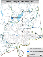
MS4 Maps
| Lake George Area MS4 Map | Queensbury & Glens Falls Area MS4 Map | Queensbury MS4 Map |
|---|---|---|
 |
 |
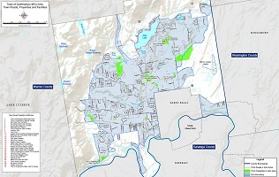 |
In Warren County, the Town of Queensbury is a regulated municipality under the NYS Department of Environmental Conservation (DEC) Municipal Separate Storm Sewer System (MS4) Program. All municipalities regulated under the MS4 program are required to implement Best Management Practices (BMPs) to control stormwater runoff. The purpose of these regulations is to help protect and improve the quality of public waterbodies in more densely populated areas of the state. These regulations outline a large number of tasks (formatted as six "minimum measure") which the municipality must undertake to be in compliance with these mandates.
The six minimum measures which Warren County must undertake consist of the following:
MM1: Public education and outreach
MM2: Public involvement and participation
MM3: Illicit discharge detection and elimination
MM4: Construction site runoff control
MM5: Post construction stormwater management
MM6: Pollution prevention and good housekeeping for municipal operations
For more information about BMPs for MS4s, Visit U.S. Environmental Protection Agency or NYS DEC
Stormwater Runoff
A significant concern in any developed area is stormwater runoff impact of the nearby waterbodies. Along roadways and parking lots, runoff is often channeled into drains and pipes, which often outlet into a stream or a lake. Impervious surfaces such as roads, rooftops and asphalt parking areas do not allow water from precipitation or snowmelt to infiltrate into the ground. As the water flows across these impervious surfaces, it can collect sediment, phosphorus, de-icing materials (sand and salt), petrochemicals and other pollutants.
Roadside ditches also contribute to stormwater runoff issues when improperly installed or poorly maintained. A poor roadside ditch can contribute to increased stormwater runoff velocity leading to increased erosion and sedimentation. During warmer months, runoff can also be significantly warmer than the stream's water, causing thermal pollution affecting the stream's aquatic communities.
These stormwater discharges are a major contributor to sedimentation/delta formation issues in the lake, and can also have significant negative impacts to a stream's aquatic community.
Calcium from road salt (if calcium chloride is used as a de-icing agent) can create habitats at the mouths of streams suitable towards zebra mussel colonization. Phosphorus transportation by sediments may create multiple problems including the eutrophication of waterbodies, causing reductions in water quality and habitat for aquatic plants and animals.
As land gets developed, typically more water runs off the land into nearby streams, often very quickly following a precipitation event. This large volume of water entering a stream in a short period of time can cause an overwidening of the stream channel in order to accommodate the increased volume of water. These channel widening processes occur through accelerated streambank erosion, and ultimately more downstream deposition (deltas).
Project Updates
Currently our main focus for the Warren County and Queensbury MS4 Programs are is storm sewer mapping and data collection within the MS4 boundaries (see right map). All of the storm sewer data and GPS locations are converted into shapefiles and mapped in ArcGIS software.
Educational References
- Water Conservation
- Rain Garden
- Managing Stormwater Runoff Using Green Infrastructure
- Managing Rainwater
- The Solution to Stormwater Pollution
- Make Your Home the Solution to Stormwater Pollution