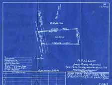
Record Series: MAPS - DEEDS & MORTGAGES
Dates: 1907 - 1957
Location: Warren County Records Storage & Archives.
Format: Small scale blueprint maps previously attached to Deed and Mortgage Books.
Arranged: By Recorded Book & Page Number
Volume: 2 cubic ft
Department: County Clerk
Legal Restrictions: None
Use Restrictions: Staff will access all records and must approve all requests for copies.
Historical Background:
It is not uncommon to have included with a recorded deed or mortgage a copy of a property survey map and to have same cited in the language of the document. It appears that the Warren County Clerk's Office found the practice of attaching maps to the recorded volume to be rather cumbersome and, as a result, instituted the practice of filing the tri-folded maps in an old metal cabinet containing woodruff drawers. It is possible That the procedure was introduced around 1925, with some backfiling on deeds and discontinued in 1957. with 1125 maps being stored independent of record books.
Description of Record Series:
Small scale blueprints (1125 items) previously attached to deeds and/or mortgages, filed separately in Deed or Mortgage Book and page order. Details included: property lines, owner names, landmarks, survey/drawing dates, Book & Page reference. Originally, multi-folded, now unfolded and refoldered using acid-free, lignin-free, unbuffered folders. Maps-Deeds, 1907-1957, 1095 items, 1.5 cf; Maps-Mortgages, 1925-1953, 30 items, .5 cf. CO-2 Schedule # 212.
Purpose of Record:
A detailed representation of a geographic area made in accompaniment to written land descriptions; many refer to property acquisitions for highway or utility acquisitions.
Other Formats: To be scanned and stored in digital format.
Finding Aids: Partial Indexing with Book, page, year, description, RSC Location & Box # ; Series location & description on inventory database.
Related Series: Deeds, Mortgages, Searches-Highway, Maps-Highway, Maps-Miscellaneous.

