
Warren County is looking to improve multi-use trails in the county and their connections with the communities through which they pass, and county leaders would like to hear from those who use these trails to learn their ideas for improvements.
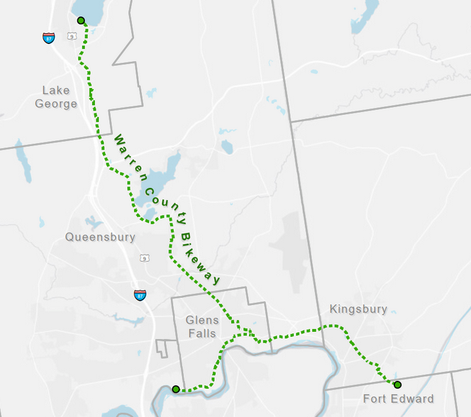
As part of an ongoing Multi-Use Trail Study being overseen by Warren County Planning and Community Development, a survey has been created to seek input from those who ride, walk or run Warren County Bikeway as well as the Feeder Canal Trail, which begins in Queensbury and ends in Fort Edward.
The survey is part of an effort to receive input from trail users that will also include a public meeting to be scheduled in the future.
An informational website has also been established to update residents and trail users about the study, informational signs will be posted along the trails and volunteers will be on hand at key locations along the trails in the coming months to discuss the project and direct users to the survey and information about the study. The survey can be accessed online here.
Ethan Gaddy, Warren County Planner, said: “Our multi-use trails provide people of all ages and abilities with a safe place to recreate, exercise, and socialize. However, there are some missing connections between the Warren County Bikeway, downtown Glens Falls, the Feeder Canal Trail and Hudson Falls that could be made. Input from residents will help the county prioritize certain types of improvements whether it be road crossings, signage, or neighborhood connections.”
The engineering firm that is overseeing the study is in the process of inventorying and evaluating existing trail conditions, crossings, and more.
Project goals include:
- Identifying connections between the Feeder Canal Trail, the Warren County Bikeway, and the nearby downtown areas
- Evaluating options to improve on-road segments
- Identifying and prioritize future improvements to the existing trail network to meet modern standards, including ADA compliance
- Evaluating and develop improvements to road crossings
- Developing a wayfinding system to allow users to navigate to and from the trail systems to the downtown areas and places of interest
- Determining trailside and trailhead amenities that are needed
- Developing a funding and implementation strategy to complete the project recommendations
Ethan Gaddy added: “The initial physical inventory findings combined with feedback from the public will be used to develop concepts for improvements to the trails and downtown connections. Our goal is to bring these trails and connections up to modern standards found on trail systems like the Erie Canal Trail or Empire State Trail to improve them for residents and visitors alike. Being able to walk or bike from your neighborhood to the Queen of American Lakes or one of our revitalizing downtowns is a remarkable quality of life feature.”
The study is a regional effort being led by Warren County Planning and Community Development along with Washington County, New York State, the City of Glens Falls, towns of Queensbury and Lake George, Village of Hudson Falls, Feeder Canal Alliance, Adirondack Cycling Advocates, Lake Champlain Lake George Regional Planning Board, Northern Border Regional Commission and Adirondack/Glens Falls Transportation Council.
A link to the informational website can be found here. Those seeking more information on the project can email [email protected].